Click for Translation


Friday, October 28, 2011


Thursday, October 27, 2011
Ascension of the Mont Toubkal
I am flying today to Marrakech in Morroco to climb the Mont Toubkal highest peak in Morroco. I am coming back on November 2nd

more info (in french): Le Toubkal (4167 m)
Point culminant de l’Afrique du Nord, le Djebel Toubkal domine de ses 4167 m les vallées encaissées où se dissimulent les très beaux villages berbères de Imlil et Tachdirt : la vie y est restée la même depuis des siècles, à l’ombre des amandiers et noyers centenaires, ponctuée par les rires des enfants et les vives couleurs des tenues des femmes berbères. Au pas des mulets de notre caravane, quittant la chaleur de la plaine pour la fraîcheur de l’altitude, vous parcourerez les terres des Bergers, où le thé à la menthe goûté dans le jour déclinant retrouve toute sa saveur. Un très beau voyage, dans le temps et dans l’espace, au fil des plateaux arides et des oasis de verdures des villages, ponctué par l’ascension du Toubkal.
C'est le massif ancien du Haut Atlas de Marrakech aux roches primitives et aux reliefs élevés et drus.
Il culmine au mont Toubkal, à 4167 m

more info (in french): Le Toubkal (4167 m)
Point culminant de l’Afrique du Nord, le Djebel Toubkal domine de ses 4167 m les vallées encaissées où se dissimulent les très beaux villages berbères de Imlil et Tachdirt : la vie y est restée la même depuis des siècles, à l’ombre des amandiers et noyers centenaires, ponctuée par les rires des enfants et les vives couleurs des tenues des femmes berbères. Au pas des mulets de notre caravane, quittant la chaleur de la plaine pour la fraîcheur de l’altitude, vous parcourerez les terres des Bergers, où le thé à la menthe goûté dans le jour déclinant retrouve toute sa saveur. Un très beau voyage, dans le temps et dans l’espace, au fil des plateaux arides et des oasis de verdures des villages, ponctué par l’ascension du Toubkal.
C'est le massif ancien du Haut Atlas de Marrakech aux roches primitives et aux reliefs élevés et drus.
Il culmine au mont Toubkal, à 4167 m
Wednesday, October 26, 2011

Monday, October 24, 2011
Saturday, October 22, 2011
Buddhist mandalas

Mandalas are works of sacred art in Tantric (Tibetan) Buddhism. The word "mandala" comes from a Sanskrit word that generally means "circle," and mandalas are indeed primarily recognizable by their concentric circles and other geometric figures. Mandalas are far more than geometical figures, however. For Tantric Buddhists, they are rich with symbolism and sacred meaning. In fact, the etymology of the word "mandala" suggests not just a circle but a "container of essence."
Overview
Simply stated, a mandala is a sacred geometric figure that represents the universe. When completed, a mandala becomes a sacred area that serves as a receptable for deities and a collection point of universal forces. By mentally entering a mandala and proceeding to its center, a person is symbolically guided through the cosmos to the essence of reality. By constructing a mandala, a monk ritually participates in the Buddha's teachings.
In Tibetan Buddhism, contemplation of sacred images is central to religious ritual, and a mandala is one of the most important of these sacred images. A Tibetan mandala is usually made with careful placement of colored sand, and accordingly is known in Tibetan as dul-tson-kyil-khor, or "mandala of colored powders." In China, Japan and Tibet, mandalas can also be made in bronze or stone three-dimensional figures. In recent years, a variety of mandalas have been created using computer graphics, although these are usually created by non-Buddhists and are not considered sacred.
Constructing a Mandala

The process of constructing a mandala is a sacred ritual. It is a meditative, painstaking process that can take days or even weeks to complete.
Before a monk may participate in the construction of a mandala, he must undergo a lengthy period of artistic and philosophical study. In the Namgyal monastery, the personal monastery of Dalai Lama, this period lasts three years.
Traditionally, four monks work together on a single mandala. The mandala is divided into quadrants with one monk assigned to each. Midway through the process, each monk receives an assistant who helps fill in the colors while the primary monk continues to work on detailed outlines.
Mandalas are constructed from the center outward, beginning with a dot in the center. With the placement of the center dot, the mandala is consecrated to a partcular deity. This deity will usually be depicted in an image over the center dot, although some mandalas are purely geometric.
Lines are then drawn through the center dot to the four corners, creating triangular geometric patterns. These lines are then used to construct a square "palace" with four gates. The monks usually keep to their own quadrant at this point.
From the inner square, the monks move outward to a series of concentric circles. Here the monks work in tandem, moving all around the mandala. They wait until each section is entirely completed before moving outward together. This ensures that balance is always maintained.
Although some mandalas are painted and serve as an enduring object of contemplation, the traditional Tibetan sand mandala, when completed, is deliberately destroyed. The sand is poured into a nearby stream or river to distribute the positive energies it contains. This ritual reminds those who painstakingly constructed the mandala of the central Buddhist teaching of the impermanence of all things.
Mandala Symbolism
In Buddhism, mandalas are rich with symbolism that evokes various aspects of Buddhist teaching and tradition. This is part of what makes the creation of a mandala a sacred act, for as they work, the monks are imparting the Buddha's teachings.
Outside the square temple are several concentric circles. The outermost circle is usually decorated with stylized scrollwork resembling a ring of fire. This ring of fire symbolizes the process of transformation humans must undergo before being able to enter the sacred territory within. It both bars the unitiated and symbolizes the burning of ignorance.
The next circle inward is a ring of thunderbolt or diamond scepters, which stands for indestructability and illumination. This is followed by a circle of eight graveyards, representing the eight aspects of human consciousness that bind a person to the cycle of rebirth. Finally, the innermost ring is made of lotus leaves, signifying religious rebirth.
The square structure in the middle of a mandala is a palace for the resident deities and a temple containing the essence of the Buddha. The square temple's four elaborate gates symbolize a variety of ideas, including:
• The four boundless thoughts: loving-kindness, compassion, sympathy and equanimity
• The four directions: south, north, east and west
Within the square palace or temple are images of deities, which are usually the Five Dyani Buddhas (the Great Buddhas of Wisdom). The iconography of these deities is rich in symbolism in itself. Each of the Dyani Buddhas represents a direction (center, south, north, east and west), cosmic element (like form and consciousness), earthly element (ether, air, water, earth and fire), and a particular type of wisdom. Each Buddha is empowered to overcome a particular evil, such as ignorance, envy or hatred. The Five Dyani Buddhas are generally identical in appearance, but are each represented iconographically with a particular color, mudra (hand gesture), and animal. See the article on the Five Dyani Buddhas for more information.
In the center of the mandala is an image of the chief deity, who is placed over the center dot described above. Because it has no dimensions, the center dot represents the seed or center of the universe.

Types of Mandalas
Tibetan Mandalas come in a variety of forms, but most are variations on the basic themes outlined above. Broadly speaking, there are two basic types of mandalas:
• Garbha-dhatu (Sanskrit: “womb world”; Japanese: taizo-kai), in which the movement is from the one to the many
• Vajra-dhatu (Sanskrit: “diamond world”; Japanese kongo-kai), from the many into one
Thursday, October 20, 2011
Back from white water kayaking

White water kayak is quite an intense experience. You have no control over the water, experience and technic would help you, but as I have none, so the first days were really tough ! I drink lots of water, swim a lot. Not as relaxing as expected, I have to admit :-)

I kayak on the Trisli River
Video of me doing a T-Rescue : White Water Kayak - Sophie doing a T-Rescue
More about the Trisuli River:
The Trishuli is named after the trishula or trident of Shiva, a powerful god in the Hindu pantheon.There is a legend that says high in the Himalayas at Gosaikunda, Shiva drove his trident into the ground to create three springs – the source of the river and hence its name Trisuli
Trisuli river starts from Betrawati (625m) and flows to Narayanghat (170m) covering distance of 141 kms. The river is approchable from Kathmandu by vehicle in 2 to 4 hours' drive and the river days would be from 4 to 7. The difficulty in class is 3+ to 4

Friday, October 14, 2011
Wednesday, October 12, 2011
Back to Kathmandu - Manaslu sum up in very short
I've just came back to Kathmandu today. Trek out via Larke Path was really good

Quick Manaslu climb sum up:
Approach: Sept 16th, after 8 days trek, I've finally made it to Base Camp. I have trek in with the donkey drivers. We had lots of work to make the way safe for the donkeys : building bridge, path, help the donkeys crossing rivers .... it was quite of an experience
Arrive at Base Camp on Sept. 24th.
First Carry: On Sept. 25th, I did a first carry to Camp 1. I carried about 15kg, and I was feeling very good. At that time, I knew that I could keep going and go up to 7000m with an heavy load. I did not sleep at Camp1 (5700m). I just went up to Camp 1 and drop a first load of gear, and went down to Base Camp (4700m)
Waiting for window: Sept. 26th and Sept 27th, it snowed a lot. Everyone went down the mountain as there was lots of avalanches between Camp 1 and Camp 2 and above in some sections.
Summit Push:
Sept 28th : Climb and sleep at Camp 1 (5700m) - load 15 kg
Sept 29th : Climb and sleep at Camp 2 (6400m) - load 30kg
Sept 30th : Climb and sleep at Camp 3 (6800m) - left behind me at Camp 2 half of the load - carry only 15kg up to Camp 3
Oct 1st : Go down to Camp 2 to pick up the remaining of my gear that I left the day before, then climb back up to Camp 3. Sleep at Camp 3
Oct 2nd : Sleep at Camp3 - wait for good weather
Oct 3rd : Climb and sleep at Camp 4 (7450m)
Oct 4th : Summit without O2 (As usual, I did carry a O2 bottle with me up to 8000m just in case, but I was feeling really good, and I did not use it. I start late, at 7am. So I did not carry my stove and pot :-). After summit, I went down to Camp 4 and sleep at Camp 4
Oct 5th : Went down to Base Camp
Oct 6th : Packing my bags at Base Camp
Oct 7th : Went down to Samogon, and start my trek out via Lake Pass


Sophie summit Manaslu on Oct 4th 2011
WITHOUT Oxygen
Quick Manaslu climb sum up:
Approach: Sept 16th, after 8 days trek, I've finally made it to Base Camp. I have trek in with the donkey drivers. We had lots of work to make the way safe for the donkeys : building bridge, path, help the donkeys crossing rivers .... it was quite of an experience
Arrive at Base Camp on Sept. 24th.
First Carry: On Sept. 25th, I did a first carry to Camp 1. I carried about 15kg, and I was feeling very good. At that time, I knew that I could keep going and go up to 7000m with an heavy load. I did not sleep at Camp1 (5700m). I just went up to Camp 1 and drop a first load of gear, and went down to Base Camp (4700m)
Waiting for window: Sept. 26th and Sept 27th, it snowed a lot. Everyone went down the mountain as there was lots of avalanches between Camp 1 and Camp 2 and above in some sections.
Summit Push:
Sept 28th : Climb and sleep at Camp 1 (5700m) - load 15 kg
Sept 29th : Climb and sleep at Camp 2 (6400m) - load 30kg
Sept 30th : Climb and sleep at Camp 3 (6800m) - left behind me at Camp 2 half of the load - carry only 15kg up to Camp 3
Oct 1st : Go down to Camp 2 to pick up the remaining of my gear that I left the day before, then climb back up to Camp 3. Sleep at Camp 3
Oct 2nd : Sleep at Camp3 - wait for good weather
Oct 3rd : Climb and sleep at Camp 4 (7450m)
Oct 4th : Summit without O2 (As usual, I did carry a O2 bottle with me up to 8000m just in case, but I was feeling really good, and I did not use it. I start late, at 7am. So I did not carry my stove and pot :-). After summit, I went down to Camp 4 and sleep at Camp 4
Oct 5th : Went down to Base Camp
Oct 6th : Packing my bags at Base Camp
Oct 7th : Went down to Samogon, and start my trek out via Lake Pass

Sophie on the trek out : Manaslu Circuit Larke Pass
Pictures, Videos, .... more coming later .... Friday, October 7, 2011
sommet du MANASLU le mardi 4 octobre 2011
Paris, jeudi 6 octobre 2011
Sophie vient de me téléphoner vers 17h00 pendant quelques secondes, avec un téléphone qu'elle a emprunté, pour me dire qu'elle avait atteint le sommet du MANASLU le mardi 4 octobre 2011 et qu'elle allait bien. Qu'elle était fière de son succès et que dès qu'elle serait dans un lieu où elle pourrait communiquer elle donnerait plus de précisions.
Elle voulait surtout rassurer tout le monde après un challenge si difficile.
Je dois dire que, pour la première fois, j'étais inquiet.
Yves Denis
Sophie vient de me téléphoner vers 17h00 pendant quelques secondes, avec un téléphone qu'elle a emprunté, pour me dire qu'elle avait atteint le sommet du MANASLU le mardi 4 octobre 2011 et qu'elle allait bien. Qu'elle était fière de son succès et que dès qu'elle serait dans un lieu où elle pourrait communiquer elle donnerait plus de précisions.
Elle voulait surtout rassurer tout le monde après un challenge si difficile.
Je dois dire que, pour la première fois, j'étais inquiet.
Yves Denis
Monday, September 26, 2011
Manaslu - Climbing Strategy
MANASLU EXPEDITION - CLIMBING STRATEGY

I will climb Manaslu with no Guide, Porter, or Sherpa. I will be self-sufficient, meaning that I will need to carry up to the mountain all my belongs: Tent, Gas, Food, Personal Gear ...
I have estimate that my bag pack should weight ~28kg.
Instead of carrying 28kg in once, I will do carry. Or in other words, I will carry about 15kg of gear up to half way between each camp. Then I will depsosit the gear on the snow and attached it to a secure snow picket that I will place.
It is a totally different technic that my previous climb which will allow me to 1/ carry less in once, 2/ insure a good acclimatization as I will go high during the day and sleep low at night.
Altitude Chart

Saturday, September 24, 2011

Thursday, September 22, 2011
Manaslu Route Description
MANASLU EXPEDITION - ROUTE DESCRIPTON

Base Camp to Camp 1
BC is located at 4,665 meters and while it is well situated on rock and protected from winds, the valley’s clouds condense at this altitude and often result in significant snowfall. The climbing begins immediately out of base camp as we step onto the Manaslu Glacier. The route will be heavily crevassed. I will use fix rope over the more dangerous sections. Camp I at 5,500 meters, which is located in a comfortable col at the head of the Manaslu glacier at the foot of the North Peak, a separate satellite mountain of Manaslu. The climb from base camp to camp one takes ~3hours.
Camp 1 to Camp 2
From Camp 1, the route continues up steep slopes to a massive and often highly active icefall, but weaving between seracs, I passe underneath the icefall to reach a steep slope that will be fixed with rope up to Camp II. Camp 2 is sheltered by a series of ice cliffs at 6,300 meters. Camp two is located at the top of the serac section of the climb on a somewhat flat area safe from danger, although this campsite can receive a lot of snow accumulation. This is the most technical section of the climb and takes ~5hours.

From www.connect.in.com
Camp 2 to Camp 3
From Camp 2, the route continues up the upper glacier, traveling through a series of snow shelves before ascending a steeper snow slope to reach a large col with magnificent views of the surrounding peaks. Camp 3 is placed on a flat saddle that sits just below the col, hence the reason this campsite receives strong winds frequently. The climb from Camp 2 to Camp 3 is the less strenuous day by being one of the shortest on the mountain and takes between 1.5-3 hours.
Camp 3 to Camp 4
From Camp 3 at 6,700 meters, the route continues up the remaining glacier weaving through seracs with some short steep sections of ice and snow. Then, the route goes directly up the steeper northeast slopes, and passing through some short ice bulges to reach an upper snow slope. There is an exposed traverse with remains of past expeditions in the shape of old abandoned and destroyed tents which will take me to Camp IV at 7,300 meters. The summit, which has not been in our view since Samagaon, is now deceivingly close, however, it is still a long way to go. The climb from camp three to camp four takes ~6 hours.

Camp 4 to Summit
From Camp 4, I will climb up snow slopes which involve short, steep sections in potentially deep snow before arriving at the final pyramid slope. There is a comfortable false summit just below the true summit, which is a spot where many people stop. The true summit is reached with an exposed technical traverse for around 70 meters in linear distance. The climb from camp four to the summit takes ~7 hours with 2-4 hours for the descent to camp four.
The descent can be fast, but I will stay at Camp 4 to clean up the Camps.
Topo Map

Saturday, September 17, 2011


Tuesday, September 13, 2011
Broad Peak Summit Pictures

Sophie climbed Broad Peak, 12th highest peak in the world located in Pakistan
Sophie hopes that her outstanding effort will inspire people to do,
and to send an empowering message that Everything Is Possible!
Don't give up, believe in yourself!


Sunday, September 11, 2011
Annapurna Trek

View from Annapurna Base Camp
Annapurna Base Camp Trek

Early September is the end of the monsoon season. The cons are that I did not see any views, as it was raining and cloudy all day every day. It was not much fun to trek with this weather and be soaking wet all the time. The plus are the trekkers. In this off season, there is no big group, only individual trekking. I met every single day very interesting people, with great stories and good energy.
Here below, a group of Chinese trekkers who are celebrating the Mid-Autumn Festival at Annapurna Base Camp. I was one of those heartwarming moments when you feel being part of something different. They were singing traditional songs, and invite me to join them to eat the Mooncake that they brought from China.
Learn more about the Mooncake : http://en.wikipedia.org/wiki/Mooncake
Trek Altitude chart

I got very sick, and take my recovery very seriously. I did the Annapurna Base Camp Trek with specific goals in mind:
- Get pre-acclimatized for my coming climb. Manaslu base Camp is at 4800m
- Check myself physically : How I do, How I feel
I spent 3 nights at Base Camp and Trek up to ~4800m several times. I felt good. I noticed that I lost a lot of acclimatization, as I woke up at the morning with my visage swollen. It is a natural inflammation of your mucus due to altitude. Otherwise, I did not notice any other symptoms: headache, nausea, difficulty to breathe …
Trek Pictures
Life style: As I walked through more remote areas, I can enjoy the Gurung region traditions and lifestyle
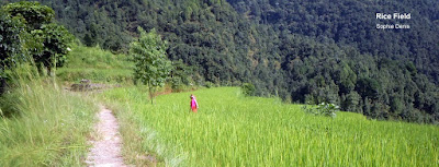


Jungle: Until Deurli, I walked mainly in the Jungle. It is full of animals. We can hear the birds singing loud, monkeys jumping trees to trees, a broad range of butterfly … , the down side are the letches. But with salt in your socks, and tiger balm on your shoes, they do not bite


Views


- Get pre-acclimatized for my coming climb. Manaslu base Camp is at 4800m
- Check myself physically : How I do, How I feel
I spent 3 nights at Base Camp and Trek up to ~4800m several times. I felt good. I noticed that I lost a lot of acclimatization, as I woke up at the morning with my visage swollen. It is a natural inflammation of your mucus due to altitude. Otherwise, I did not notice any other symptoms: headache, nausea, difficulty to breathe …
Trek Pictures
Life style: As I walked through more remote areas, I can enjoy the Gurung region traditions and lifestyle


Jungle: Until Deurli, I walked mainly in the Jungle. It is full of animals. We can hear the birds singing loud, monkeys jumping trees to trees, a broad range of butterfly … , the down side are the letches. But with salt in your socks, and tiger balm on your shoes, they do not bite


Views


Subscribe to:
Posts (Atom)