Monday, September 26, 2011

Manaslu - Climbing Strategy


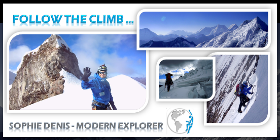
MANASLU EXPEDITION - CLIMBING STRATEGY


I will climb Manaslu with no Guide, Porter, or Sherpa. I will be self-sufficient, meaning that I will need to carry up to the mountain all my belongs: Tent, Gas, Food, Personal Gear ...
I have estimate that my bag pack should weight ~28kg.

Instead of carrying 28kg in once, I will do carry. Or in other words, I will carry about 15kg of gear up to half way between each camp. Then I will depsosit the gear on the snow and attached it to a secure snow picket that I will place.

It is a totally different technic that my previous climb which will allow me to 1/ carry less in once, 2/ insure a good acclimatization as I will go high during the day and sleep low at night.


Altitude Chart


Thursday, September 22, 2011

Manaslu Route Description


MANASLU EXPEDITION - ROUTE DESCRIPTON


Base Camp to Camp 1


BC is located at 4,665 meters and while it is well situated on rock and protected from winds, the valley’s clouds condense at this altitude and often result in significant snowfall. The climbing begins immediately out of base camp as we step onto the Manaslu Glacier. The route will be heavily crevassed. I will use fix rope over the more dangerous sections. Camp I at 5,500 meters, which is located in a comfortable col at the head of the Manaslu glacier at the foot of the North Peak, a separate satellite mountain of Manaslu. The climb from base camp to camp one takes ~3hours.


Camp 1 to Camp 2


From Camp 1, the route continues up steep slopes to a massive and often highly active icefall, but weaving between seracs, I passe underneath the icefall to reach a steep slope that will be fixed with rope up to Camp II. Camp 2 is sheltered by a series of ice cliffs at 6,300 meters. Camp two is located at the top of the serac section of the climb on a somewhat flat area safe from danger, although this campsite can receive a lot of snow accumulation. This is the most technical section of the climb and takes ~5hours.


From www.connect.in.com


Camp 2 to Camp 3


From Camp 2, the route continues up the upper glacier, traveling through a series of snow shelves before ascending a steeper snow slope to reach a large col with magnificent views of the surrounding peaks. Camp 3 is placed on a flat saddle that sits just below the col, hence the reason this campsite receives strong winds frequently. The climb from Camp 2 to Camp 3 is the less strenuous day by being one of the shortest on the mountain and takes between 1.5-3 hours.


Camp 3 to Camp 4


From Camp 3 at 6,700 meters, the route continues up the remaining glacier weaving through seracs with some short steep sections of ice and snow. Then, the route goes directly up the steeper northeast slopes, and passing through some short ice bulges to reach an upper snow slope. There is an exposed traverse with remains of past expeditions in the shape of old abandoned and destroyed tents which will take me to Camp IV at 7,300 meters. The summit, which has not been in our view since Samagaon, is now deceivingly close, however, it is still a long way to go. The climb from camp three to camp four takes ~6 hours.


Camp 4 to Summit


From Camp 4, I will climb up snow slopes which involve short, steep sections in potentially deep snow before arriving at the final pyramid slope. There is a comfortable false summit just below the true summit, which is a spot where many people stop. The true summit is reached with an exposed technical traverse for around 70 meters in linear distance. The climb from camp four to the summit takes ~7 hours with 2-4 hours for the descent to camp four.


The descent can be fast, but I will stay at Camp 4 to clean up the Camps.

Topo Map

Tuesday, September 13, 2011

Broad Peak Summit Pictures


Sophie climbed Broad Peak, 12th highest peak in the world located in Pakistan


After summiting Lhotse, 4th highest peak in the world located in Nepal, and Cho Oyu, 6th highest peak in the world located in Tibet, Sophie found the mental and physical strength to climb and summit Broad Peak on July 25th 2011, at her 4th Broad Peak' Summit attempt in one month.

Sophie hopes that her outstanding effort will inspire people to do,
and to send an empowering message that Everything Is Possible! 
Don't give up, believe in yourself!


Sunday, September 11, 2011

Annapurna Trek

View from Annapurna Base Camp

Annapurna Base Camp Trek


Early September is the end of the monsoon season. The cons are that I did not see any views, as it was raining and cloudy all day every day. It was not much fun to trek with this weather and be soaking wet all the time. The plus are the trekkers. In this off season, there is no big group, only individual trekking. I met every single day very interesting people, with great stories and good energy.


Here below, a group of Chinese trekkers who are celebrating the Mid-Autumn Festival at Annapurna Base Camp. I was one of those heartwarming moments when you feel being part of something different. They were singing traditional songs, and invite me to join them to eat the Mooncake that they brought from China.
Learn more about the Mooncake : http://en.wikipedia.org/wiki/Mooncake


Trek Altitude chart


I got very sick, and take my recovery very seriously. I did the Annapurna Base Camp Trek with specific goals in mind:
- Get pre-acclimatized for my coming climb. Manaslu base Camp is at 4800m
- Check myself physically : How I do, How I feel


I spent 3 nights at Base Camp and Trek up to ~4800m several times. I felt good. I noticed that I lost a lot of acclimatization, as I woke up at the morning with my visage swollen. It is a natural inflammation of your mucus due to altitude. Otherwise, I did not notice any other symptoms: headache, nausea, difficulty to breathe …


Trek Pictures  
 
Life style: As I walked through more remote areas, I can enjoy the Gurung region traditions and lifestyle


Jungle: Until Deurli, I walked mainly in the Jungle. It is full of animals. We can hear the birds singing loud, monkeys jumping trees to trees, a broad range of butterfly … , the down side are the letches. But with salt in your socks, and tiger balm on your shoes, they do not bite


Views


Wednesday, September 7, 2011

Annapurna Trek Itinerary

Annapurna Trek Itinerary

DAY #1
  • Drive from Pokhara to Phedi
  • Phedi to Pothana: The trail climbs through Dhampus from where you will start to get a splendid view of the Annapurma range, and then gradually ascends a forested trail paved with stones. There is a short steep climb to Pothana at 1,890m 
  • Pothana - Landruk: The trail climbs through forest to a clearing on top of the hill at 2010m, where there are views of Annapurna South and Hiunchuli. From there make a steep decent, through forests alive with birds, ferns and orchids into a huge side canyon of the Modi Khola. From here it's an easy walk, past fields, a school before the trail drops a bit to the flagstone streets of Landruk, a Gurung village at 1,565m.
DAY #2

  • Landruk to New Bridge: The narrow trail to the sanctuary turns north up the Modi Khola valley passing alongside rice terraces then through forests and a short walk up the river bed leads to New Bridge (1,340m).
  • New Bridge to Chommrong: A stiff climb leads to Jhinudanda (1,780m) and from the trial continues to climb steep uphill along a treeless ridge to Taulung at 2180m. A short distance from Taulung, the trail rounds a bend and enters the upper part of Chhommrong at 2,170m.
  • Chommrong - Bamboo: Leaving Chommrong, the trail descends on a stone staircase and crosses the Chommrong Khola. Climbing high above the Modi Khoa on it's west bank, the trail passes through the tiny settlement of Tilche in forests of bamboo, rhododendron and oak. The trail continues in rhododendron forests, climbing to Khuldigar at 2,540m. It is then a short distance on a muddy trail to Bamboo at 2,335m.
  • Bamboo to Dovan: The trail climbs steeply through stands of bamboo, then through rhododendron forest up the side of the canyon, occasionally dropping slightly to cross tributary streams. Trail cleared up shotly before Dovan at 2,505m 
DAY #3


  • Dovan to Deurali: Trail ascending continuously to Hinko. The trail crosses a ravine and a major avalanche track just beyond Hinku, then climbs through large boulders. About half an hour beyond Hinku is Deurali at 3,200m.
DAY #4

  • Deurali - Machhapuchhre Base Camp
  • Above Deurali, the valley widens and becomes less steep and you can see the gates to the sanctuary. As the trail continues into the sanctuary, it crosses two wide avalanche tracks on a narrow trail that huddles up against the cliffs. The trail then descends to meet the Modi Khola and follows the river to Bagar at 3300meters. From there cross a moraine and a stream and finally reaches Machhapuchre Base Camp at 3,700m.
  • Machhapuchre Base Camp (MBC) up to Singu Chuli Base Camp (cave camp) - sleep at MAC: From Machhapuchre base camp cross the rubble - strewn snout of the South Annapurna Glacier and follow the Modi Khola on its true right bank until it is joined by a tributary stream from the West Annapurna Glacier. Follow this north - west over moraines and grassy meadows to a rock overhang before the snout of the West Annapurna Glacier
DAY #5
  • Machhapucharee Base Camp to Annapurna Base Camp: It's an about two hour climb to Annapurna base camp (ABC) 4,130m. Once at ABC, I will do an acclimatization hike up to 4800m, to back down and sleep at ABC
DAY #6
  • Annapurna Base Camp up to Tharpu Chuli Camp: Acclimatization hike to Tharpu Chuli Camp at 5,230m. Sleep at Annapurna Base Camp to consolidate a good acclimatization. (after being sick , I want to take it easy and rebuild my acclimatization if needed)
DAY #7
  • Annapurna Base Camp to Chomrong
DAY #8
  • Chomrong to Naya Pul: On the way down  will d a detour to Poon, stunning view point.
 DAY #9
  • Naya Pul drive to Pokhara


Sunday, September 4, 2011

Pokhara Buddhist Monastery, a masterpiece


I visit today a Buddhist Monastery. It is a masterpiece. The paintings are splendid, with an impressive level of details. The paintings are telling the buddha story. You walk in the monastery reading the wall painting as you would read a book. It is a must !


More of Sophie's Actities & Pictures  in Pokhara